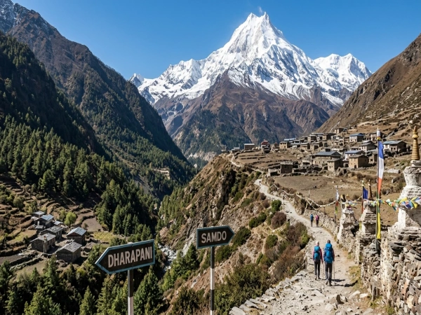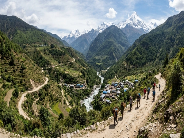
Jagat to Dharapani covers the entire upper Manaslu Circuit, not a single walking day. The section runs eight to ten days on foot, climbing from around 1,340 meters at Jagat to the Larkya La pass at 5,106 meters, then dropping steeply to Dharapani at about 1,860 meters, where the Annapurna Circuit begins.
Everything changes across this section. Subtropical gorge becomes pine forest, then alpine moraine and glacier. Hindu hill villages become Tibetan Buddhist settlements. Lodge prices roughly double. The walking stays moderate until the pass day, which is genuinely demanding regardless of fitness level.
How Many Days Jagat to Dharapani Takes
Itineraries run between eight and ten walking days depending on acclimatization stops. Fewer than eight is possible but unwise, since the altitude gain above Namrung needs time to absorb. The difference between a good and a bad package is almost entirely how much rest gets scheduled at Samagaun.
Which Stages the Route Breaks Into
Each stage has its own altitude band, weather, lodge standard and cultural character. The transitions happen gradually enough that you notice them in the buildings and vegetation rather than from one morning to the next.
· Jagat to Deng
Six to eight hours over roughly nineteen kilometers, climbing past Salleri, Sirdibas and Philim where the Tsum Valley trail branches right. Deng sits at around 1,860 meters. Autumn days reach eighteen to twenty five degrees with nights near ten. Bamboo and rhododendron replace subtropical growth, and Tibetan influence first shows in the buildings. Rooms run three to six hundred rupees.
· Deng to Namrung
Six to seven hours through Rana, Bihi Phedi and Ghap at around 2,160 metres, with mani walls appearing and the forest turning to pine and oak. Namrung sits at around 2,630 meters, days fifteen to twenty degrees, nights near five. The route has the best lodges, some with attached bathrooms and bakeries, for around five hundred to a thousand rupees.
· Namrung to Lho
Four to six hours climbing through Lihi and Sho, with barley and potato replacing rice terraces and houses turning flat roofed in the Tibetan style. Lho sits at around 3,180 meters, days ten to fifteen degrees, nights near freezing. Ribung Gompa sits above the village and the Manaslu views rank among the best anywhere on the circuit.
· Lho to Samagaun
Three to six hours passing Shyala at around 3,500 meters, where many trekkers stop instead to split the altitude gain. Samagaun sits at around 3,530 meters, the largest village on the route, days eight to twelve degrees and nights below freezing. The valley opens into a broad alpine basin with yak herds grazing across the slopes.
· The Acclimatization Day at Samagaun
Not optional in any sensible itinerary, since skipping it causes most evacuations on this route. Birendra Lake sits an hour away. Manaslu Base Camp at 4,800 meters makes a hard six to eight hour hike, while Pungyen Gompa at 4,000 meters offers a gentler four hour option. Budget two to three thousand rupees for the extra day.
· Samagaun to Samdo
Three to four hours north toward the Tibetan border, with tree cover disappearing entirely into high alpine pasture. Samdo sits at around 3,870 meters, with days around 10 degrees and nights well below freezing year-round. Tibetan refugees settled the village, which still trades across a nearby pass, and the low houses are built to withstand the wind.
· Samdo to Dharamsala
Four to five hours to Dharamsala, also called Larkya Phedi, at around 4,460 meters. This is a basic high camp rather than a village, existing purely to position trekkers for the pass. Nights drop well below freezing in every season, accommodation is dormitory-style and crowded, and beds run eight hundred to fifteen hundred rupees.
· Crossing Larkya La to Bimthang
The hardest day of the circuit, eight to eleven hours starting between three and four in the morning. Larkya La sits at 5,106 meters, with temperatures at the pass reaching minus fifteen with wind chill. The climb is long rather than technical. The descent drops nearly 1,400 meters to Bimthang at around 3,590 meters, a glacial meadow many trekkers name their favorite stop.
· Bimthang to Dharapani
Seven to nine hours descending around 1,760 meters through rhododendron and pine, passing Yak Kharka, Gho and Tilije. Some itineraries split this at Tilije around 2,300 meters. Dharapani sits around 1,860 meters, with shops, lodges, and road access. Prices drop here because supplies arrive by vehicle, with rooms back around 400 to 800 rupees.
Above 3,000 meters altitude becomes a genuine medical concern. Headache, nausea and breathlessness at rest all signal a problem that worsens with further climbing. Never ascend with symptoms present, and tell your guide honestly how you feel rather than minimizing it for the group.
Where to Stay and What It Costs
Teahouses exist at every overnight stop, unlike a couple of decades ago, when this trek required camping support. Standards drop steadily with altitude, and the gap between Namrung and Dharamsala is substantial in both comfort and price.
· How Lodges Change With Height
Lower lodges offer reasonable twin rooms, some with attached bathrooms. Above Samagaun, expect plywood partitions, shared squat toilets and one heated dining room where everybody gathers after dark. A sleeping bag rated to minus ten matters from Namrung upward, since rooms are unheated everywhere.
Hot showers cost three to six hundred rupees where available and disappear above Samdo. Charging devices costs two to five hundred per device since power is solar. Wifi runs three to six hundred but rarely works. Lodges often reduce room charges if you eat dinner and breakfast there.
· What a Daily Budget Looks Like
Budget three to five thousand rupees daily for food and accommodation combined, roughly twenty two to forty dollars. That rises toward the upper end above Samagaun and falls once you reach Dharapani. Across the full section, expect twenty five to fifty thousand rupees excluding permits, guide and transport.
What Food Is Available and What It Costs
Dal bhat remains the best value everywhere because it comes with free refills and gets cooked fresh. Prices rise steadily with altitude because every ingredient arrives by mule train or on someone’s back. Expect prices to be five to eight hundred rupees lower down and nine hundred to fifteen hundred above Samagaun.
Tea costs 100 to 300 rupees. Noodles, soup, momos, chapati and basic Western dishes appear on most menus at similar price points. Avoid meat above Namrung since it travels badly without refrigeration. Garlic soup genuinely helps acclimatization and appears on every menu along the route.
Who Lives in the Nubri Valley
From Deng onward, you walk through the Nubri Valley, home to Tibetan communities that have lived here for centuries. The culture is Tibetan Buddhist rather than Hindu, and it shows in the buildings, the fields and the daily rhythm of each village.
· Houses and Monasteries of the Nubri Valley
Buildings change from sloped metal roofs to flat roofed stone houses with firewood stacked along the edges for winter. Windows feature carved wooden frames painted red and blue, and courtyards hold prayer-flag poles marking each household.
Ribung Gompa at Lho is the largest monastery on the route. Mani walls carved with mantras line the trail and should always be passed on the left. Samdo families still trade across the Tibetan border, and most households still earn their living by herding yaks.
Which Vehicles Reach Dharapani and What They Cost
No vehicle reaches anywhere between Jagat and Bimthang. This entire section is walking only, with every supply moving by mule train or porter. Dharapani is where road access finally resumes on the Annapurna side of the pass.
· Jeep from Dharapani to Besisahar
The road is rough, narrow, and cut into a steep hillside, making Four Wheel Drive essential rather than preferable. The journey takes four to five hours. Shared jeeps cost roughly 1,500 to 2,500 rupees per person, while private jeeps run 15,000 to 25,000 rupees for the vehicle.
From Besisahar, buses continue to Kathmandu or Pokhara for 700 to 1,200 rupees over six to seven hours. Total travel time from Dharapani to Kathmandu runs nine to eleven hours, so most trekkers break the journey at Besisahar overnight rather than pushing through.
Permits and Practical Tips Before Leaving Jagat
Carry enough cash in rupees for the whole section, since there are no ATMs between Jagat and Besisahar. Foreign trekkers need a licensed guide for the restricted section, and checkpoints verify permits at Philim, Namrung and elsewhere, so keep them accessible rather than buried.
FAQ 1: How long does Jagat to Dharapani actually take?
A: Eight to ten walking days depending on acclimatization stops. Fewer than eight increases altitude sickness risk considerably before the Larkya La crossing at 5,106 meters.
FAQ 2: What does this section cost per person?
A: Roughly twenty five to fifty thousand rupees for food and lodging across the section, plus permits, guide fees and around two to three thousand for transport out.