Dharapani to Samdo covers roughly four to five walking days across the western half of the Manaslu Circuit, climbing from about 1,860 meters to the Larkya La at 5,106 meters before dropping to Samdo at 3,875 meters. It is the circuit walked backward, and the altitude profile is the reason almost nobody does it.
The standard route runs anticlockwise from Machha Khola up the Budhi Gandaki, reaching Samdo on day eight or nine with a rest day at Samagaun already behind. Reversed, you reach the same pass in three or four days from a valley floor. The walking is identical. The physiology is not.
Why Dharapani to Samdo Runs Against the Circuit
Permits and checkpoints are arranged for east-to-west travel. The Restricted Area Permit covers the corridor from Jagat through to Bimthang, with checkpoints at Jagat, Philim and Namrung designed to register trekkers entering from the Budhi Gandaki side. Entering from Dharapani puts you through that system backward.
· Why the Acclimatization Ladder Runs Backward
Walking the standard direction, you sleep at 2,630m in Namrung, 3,180m in Lho, 3,530m in Samagaun with a full rest day, then 3,875m in Samdo and 4,460m at Dharamsala. Six nights above 2,500 meters before the pass. The body has time to adjust.
In reverse, you sleep at Dharapani (1,860 m), Tilije (2,300 m), Bimthang (3,720 m), then cross at 5,106m. That is a gain of nearly 1,400 meters in a single morning from your highest sleeping altitude. No intermediate lodge between Bimthang and the pass breaks it up.
Which Stages the Route Covers
Four to five days of walking, with the pass day dominating everything. Distances are moderate, but the climb profile is severe in this direction.
· Dharapani to Tilije and Gho
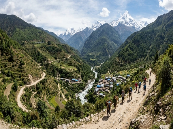
Dharapani sits at 1,860 to 1,963 meters in the Marsyangdi valley, where the Manaslu Circuit meets the Annapurna Circuit. The trail leaves the main valley and turns up the Dudh Khola, a side valley running northwest toward the glaciers.
Tilije sits around 2,300 meters, and Gho around 2,560 meters, both reached within four to six hours. Pine and rhododendron forest replaces the terraced farmland below. Both have teahouses, and splitting here rather than pushing to Bimthang makes genuine sense for acclimatization.
· Gho to Bimthang
Five to seven hours climbing steadily through forest that thins noticeably with altitude. The valley opens out, and the glaciers become visible ahead. This is the last comfortable stage before the pass, and the scenery through here is widely considered the best on the whole circuit.
Bimthang sits at 3,590 to 3,720 meters in a broad glacial meadow surrounded by peaks. Many trekkers walking the standard direction name it their favorite overnight stop. Spending two nights here rather than one is the only real acclimatization available on this side.
· Bimthang to Larkya La
The climb to the pass takes five to seven hours from Bimthang, gaining roughly 1,400 meters across moraine and often snowfield. Starting before dawn matters because afternoon wind across the exposed upper section is severe. Head torches are essential for the first two hours.
Larkya La sits at 5,106 meters, sometimes cited as 5,160. Temperatures at the top reach minus fifteen with wind chill even when the valleys below are mild. Snow is possible in any season. This is the day when the reverse direction stops being a scheduling preference and becomes a medical risk.
· Larkya La to Dharamsala
The descent east drops roughly 650 meters to Dharamsala, also called Larkya Phedi, at 4,460 to 4,470 meters. This takes two to three hours. Walking the standard direction, trekkers climb this stretch rather than descend it, which is considerably harder.
Dharamsala is a high camp rather than a village, existing only to position trekkers near the pass. Accommodation is dormitory-style and basic, nights drop well below freezing year-round, and sleep quality is poor simply because of the altitude.
· Dharamsala to Samdo
Four to five hours descending to Samdo at 3,860 to 3,875 meters, following the valley down toward the Tibetan border. Tree cover is absent entirely, replaced by high alpine pasture with yaks grazing beneath bare rock faces and glaciers.
Samdo is a genuine village rather than a camp, settled by Tibetan refugees who still trade across a nearby pass into Tibet. Houses are low, flat-roofed and built against constant wind. Arriving here means the hardest altitude is behind you.
What the Weather Does at Each Altitude
Four climate bands across four days, which catches people out badly in this direction because the change comes faster than the standard route.
Dharapani to Gho stays temperate, with autumn days around 15 to 20 degrees and nights near 5. Gho to Bimthang turns cool alpine, with days at eight to twelve degrees and nights below freezing. Dharamsala and above is high alpine, freezing every night in every season. Samdo sits at five to ten degrees by day, well below freezing overnight.
Monsoon between June and August brings heavy rain lower down and snow on the pass. Winter closes Larkya La regularly. Autumn, from late September to November, and spring, from March to May, are the only reliable windows.
Where to Stay and What It Costs
Teahouses exist at every stop on this section, though standards drop sharply above Bimthang.
· How Lodges Change With Height
Dharapani, Tilije and Gho have reasonable lodges with twin rooms and shared bathrooms, running roughly four to eight hundred rupees. Supplies arrive by road at Dharapani, so prices and comfort are both better here than anywhere higher.
Bimthang has simpler lodges at six hundred to twelve hundred rupees, with shared facilities and unheated rooms. Dharamsala is dormitory-style at eight hundred to fifteen hundred rupees, often crowded, with no hot showers at all. Samdo runs six hundred to twelve hundred with basic shared facilities.
· What a Daily Budget Looks Like
Budget three to five thousand rupees daily for food and lodging combined, roughly twenty-two to forty dollars. Costs peak at Dharamsala, where everything arrives on a mule. Across the full section, expect fifteen to twenty-five thousand rupees per person, excluding permits, guide, and transport.
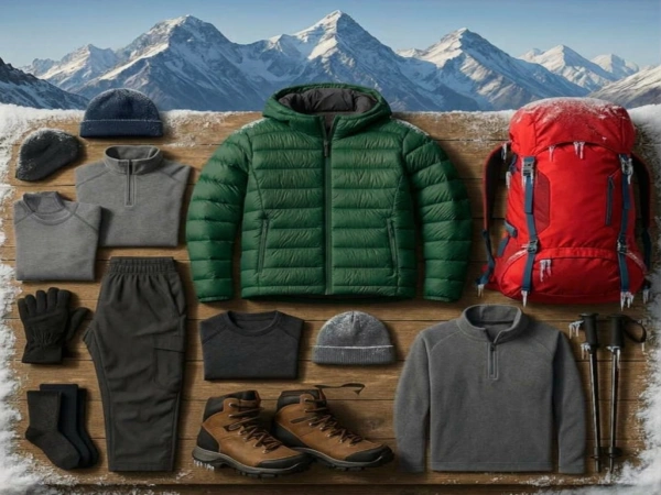
A sleeping bag rated to minus ten matters from Bimthang upward since rooms are unheated. Charging devices cost two to five hundred rupees per device at higher lodges, and Wi-Fi, where it exists, runs three to six hundred and rarely works.
What Food Is Available on This Section
Dal bhat remains the best value everywhere because it comes freshly cooked with free refills. Prices run five to eight hundred rupees at Dharapani and Tilije, climbing to nine hundred to fifteen hundred at Dharamsala and Samdo. Tea costs one to three hundred.
Noodles, soup, momos, chapati and basic Western dishes appear on most menus. Avoid meat above Bimthang since it travels without refrigeration. Garlic soup genuinely helps acclimatization and appears everywhere. Carry snacks, especially on pass days, because lunch stops are far apart.
Who Lives Along the Route
The culture shifts as decisively as the altitude does across this section.
· Houses and Monasteries Along the Dudh Khola
Lower villages around Dharapani and Tilije are Gurung and Magar, with sloped metal roofs and terraced maize and millet fields. Buildings sit on hillsides above the river with prayer flags appearing occasionally rather than constantly.
From Bimthang eastward, the architecture turns Tibetan. Flat-roofed stone houses stacked with firewood along the edges, carved wooden window frames painted in reds and blues, and courtyards holding prayer flag poles. Mani walls carved with Buddhist mantras line the trail and should always be passed on the left.
Samdo households keep yaks and trade across the border. The village sits in an open basin ringed by peaks, with Manaslu visible from several points on clear mornings. People here are used to trekkers, though the numbers remain far lower than Annapurna or Everest.
Which Vehicles Reach Each Point
· Jeep Access at Dharapani
Dharapani sits on the Annapurna Circuit road, so jeeps run from Besisahar. The road is rough, narrow, and cut into a steep hillside, making Four Wheel Drive essential. The journey takes four to five hours, with shared jeeps at fifteen hundred to twenty-five hundred rupees per person and private jeeps at fifteen to twenty-five thousand rupees for the vehicle.
Beyond Dharapani, nothing drives. The Dudh Khola valley toward Bimthang has no road, and the entire section through to Samdo moves by foot, mule train, and porter. Road access only resumes far down the other side of the circuit.
From Besisahar, buses continue to Kathmandu or Pokhara for seven hundred to twelve hundred rupees across six or seven hours.
Practical Notes Before Attempting This Direction
Speak with a registered agency before committing to this direction. Permits are arranged through an agency with a licensed guide regardless, and most will advise against the reverse route or decline to arrange it. Take that advice seriously rather than shopping around until somebody agrees.
If you do walk it, build in two nights at Bimthang minimum and treat any headache, nausea, or breathlessness at rest as a reason to descend rather than continue. Carry enough cash in rupees since no ATM exists between Besisahar and the far side of the circuit.
FAQ 1: Can the Manaslu Circuit be walked from Dharapani?
A: Physically, yes, though guides advise against it. The climb from 1,860m to the 5,106m pass in three or four days leaves no time for proper acclimatization on the Bimthang side.
FAQ 2: Does any vehicle reach beyond Dharapani toward Bimthang?
A: No. The Dudh Khola valley has no road, so everything beyond Dharapani is reached on foot, by mule, or by porter until the far side of the circuit.